I’ve always had a positive bias toward infrastructure projects. I like new constructions and effective infrastructure. If they are green, even better. But, when it comes to the Alto high-speed train, I’m not too enthusiastic because of the negative impact it will have on agriculture. As we will see, depending on the path the train will take and the infrastructure built, it has the potential to have a large impact on farms along its path.
This post raises the point that the detours imposed on farms are likely to generate significant recurring costs. Hence, the focus is how the high-speed train will disrupt the movement of farm machinery and cause farms to make in some cases long detours to access their fields. I will not touch on other potential impacts to farms like field drainage, vibrations, and issues related to the expropriation of land and buildings.
About Alto high-speed train project
I will be brief because you likely have background knowledge of the high-speed train project. If not, you want to learn more about the high-speed train by visiting Alto’s website or the Wikipedia page, among the many resources online.
The Alto high-speed train is set to link Toronto and Québec City with stops in Peterborough, Ottawa, Montréal, Laval and Trois-Rivières. It will be an electric train with a top speed over 300 km/h. Alto expects it will serve as many as 24 million passengers annually by 2055.
The high-speed rail will be very different from a conventional passenger train. There will be no crossings of the high speed rail to ensure safety. This means that, unlike a conventional train, farmers will not be able to cross a high-speed rail line that goes through their land. The high-speed rail will be an insurmountable barrier except on roads where overpasses are built. The rail will have a 60‑metre-wide footprint. I expect this is the minimum space the rail will take because there will also be access roads for maintenance.
Michael Schabas explains in his report submitted to the Senate that a greenfield alignment, i.e., through agricultural land or forests, is less expensive than a brownfield alignment, which interferes with existing infrastructure. The implication is that, out of concern for the total cost of the project, the incentives for Alto will be to choose an alignment through agricultural land. Alto states that the high-speed rail alignment will limit impacts on agricultural land, that it will prioritize negotiated agreements, and offer fair, long-term compensation.
The high-speed train network will span about 1,000 km, most of it in rural areas. Assuming that the high-speed rail is 60 metres wide, this means a total in the order of 15,000 acres for the rail line. Based on FCC farmland values report, let me assume that land is priced on average at $15,000 per acre along the route for the high-speed train.1 In total, this would mean Alto would spend about $225 million to purchase land. Assuming a 100 metres wide footprint, the project would require 24,700 acres of land and the expenditure on land grows to $375 million. This is chump change compared to the working assumption that the high-speed train will cost between $60 billion and $90 billion.
Impacts of the high-speed train on farms
Thus far, Alto has published a map of the corridor that contains the future train’s alignment (route). The corridor is about 10 kilometres wide, much larger in some areas. Alto will narrow the corridor width, beginning with the Montreal-Ottawa segment in late 2026.
To illustrate the impacts of Alto high-speed train on agriculture, I will consider a fictional dairy farm situated in Cape-Santé, west of Québec City. In the example, the total impact on the farm combines three mechanisms: land loss, detour distances, and the need to intensify production on remaining land.
Like many farms across the country, the fictional farm has expanded over the years and purchased land to feed its growing herd. The agricultural land market is competitive and plots rarely come up for sale. The farm has bought land next to its installations but also had to purchase land several kilometres away.
Figure 1 shows in blue the location of fields for a fictional farm. I think those fields are a fair representation of what an actual farm could own. The green dot locates the farm facilities. The red line is a hypothetical route for the Alto train.2 I made it so that it crosses some of the farms’ fields but does not directly affect the farm facilities. As such, there is no issues related to expropriation of the farm installations to consider in the example. The train crosses plots c, d and e. I will refer to the two parts of these plots as north and south, with the northern part above the rail line and the southern part below the rail line.
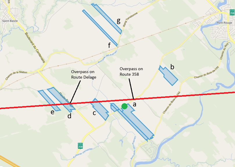
Note: The areas delineated in blue are the fields exploited by the fictional farm. The green dot locates the farm facilities. The red line shows a hypothetical route for the Alto train. The scenarios consider two hypothetical overpasses on Route Delage and Route 358.
The train removes about 13 acres of farmland, slightly more than 2% of the farm’s land. This is a direct impact to the farm. It would seem that the impacts of the high-speed train should be relatively moderate in this case. We will see that this might not be the case once indirect costs are taken into account. The magnitude of these costs depends on the infrastructure Alto will build.
One of the impacts of the Alto train will be detours farms will have to make. As previously explained, there will be no private crossings of the high-speed rail line, unlike for a conventional train. I do not expect Alto will build overpasses for each road the train will cross because overpasses are costly. There are several roads near the farm that are crossed by the hypothetical train route. I consider scenarios regarding the construction of overpasses on two of these roads. In the first scenario, I assume an overpass for Route Delage only. It would make sense to build an overpass for that road because it leads to Saint-Basile-Station. For the second scenario, I assume the construction of an overpass on Route 358 (Rang Saint-Joseph). In the third scenario, there are overpasses on the two roads. For the three scenarios, I assume that the overpasses are sufficiently large to accommodate farm machinery. A fourth scenario I will not consider is no overpass on either of these roads. This is a possibility given the high cost of building an overpass. In that case, the farm would effectively lose access to fields north of the rail line. The farm could make a detour through Route 138 and Route 365, assuming an overpass on that road, but it would be so long that it is not feasible.
Several assumptions about the size of the farm and its activities are necessary to calculate the monetary impact of the Alto train. If you find an assumption not reasonable, contact me by email and I’ll make the necessary corrections. The total farmland in Figure 1 is about 590 acres, which should suffice for a farm with a milk quota of 265 kg of butterfat per day. This makes it a large dairy farm in Quebec. I assume the farm makes the following number of trips to its fields over a year.
- Manure: 470 trips
- Silage corn: 244 trips
- Corn and soybean: 92 trips
- Hay: 294 trips
This does not include trips for seeding, applying fertilizer and other reasons. I augment the number of trips to a field by 5% to take into account all the other reasons for the farm travelling to a field. I allocate the number of trips proportional to the size of each field. I also do not consider detours to suppliers and detours the labour may need to make to get to the farm.
Overpass for Route Delage
Table 1 shows the calculation of the cost to the farm if an overpass is built on Route Delage only. The high-speed rail does not affect access to plots a, the southern part of plot c, the southern part of plot d and the northern part of plot e. The farm needs 18.1 km long detour through Saint-Basile-Station to access plot b. Accessing the northern part of plot c would require a 9.7 km long detour. However, given its small size, it would make sense for the farm to sell the northern part og that plot.3 The farm must make a small 0.2 km detour to access to the northern part of plot d. The southern part of plot e becomes inaccessible by road. Either the farm would have to sell that plot, negotiate an access with another farm, or use an access road along the train track, if one is built. I will assume for the calculations that the farm no longer exploits the southern part of plot e after the construction of the rail line. The farm has to make 6.1 km detours to access plots f and g.
In total, the Alto train causes the farm to lose 13 acres of land, assuming a 60 metres wide footprint, and 12 acres from no longer farming the northern part of plot c and the southern part of plot e. That is about 4.3% of the farm acreage. To compensate for that loss, I assume the farm exploits more intensively the rest of its land. The implication is that it has to travel more often to plots far from its installation. Thus, the distance travelled increases from the detours but also from the need to access more often plots that are on average further away. The column Extra dist (km) takes that into account.
| Plot | Km before | Km after | Km diff | Area (acre) | Trips | Extra dist (km) | Extra time (hours) |
|---|---|---|---|---|---|---|---|
| a | 0.0 | 0.0 | 0.0 | 218 | 429 | 0 | 0.0 |
| b | 2.3 | 20.4 | 18.1 | 72 | 141 | 2,681 | 89.4 |
| c - south | 1.1 | 1.1 | 0.0 | 64 | 126 | 6 | 0.2 |
| c - north | 1.1 | 3 | 0 | 0 | 0.0 | ||
| d - south | 3.3 | 3.3 | 0.0 | 13 | 26 | 4 | 0.1 |
| d - north | 3.3 | 3.5 | 0.2 | 75 | 147 | 52 | 1.7 |
| e - south | 5.2 | 9 | 0 | 0 | 0.0 | ||
| e - north | 5.2 | 5.2 | 0.0 | 51 | 100 | 23 | 0.8 |
| f | 4.0 | 10.1 | 6.1 | 40 | 78 | 511 | 17.0 |
| g | 4.9 | 11.0 | 6.1 | 42 | 83 | 545 | 18.2 |
| 3,822 | 127.4 |
Notes:
- Km before: Distance to access a field before the Alto train
- Km after: Distance to access a field after the Alto train
- Km diff: Difference in the distance to access a field
- Area (acre): Field size in acres
- Trips: number of trips a farm must make to a field annually
- Extra dist (km): Total extra distance travelled annually to a field because of the Alto train
- Extra time (hours): Extra time spent travelling annually because of the detour to access a field assuming a tractor travelling at 30 km/h
In total, the farm would have to travel 3,822 extra kilometres because of the Alto train, spending an extra 127 hours on the road. Most of the trips would be with tractors pulling a trailer and I base the calculations for such farm equipment. Transportation costs are higher for harvester and other large farm machinery. I found a whole range of hourly rates for tractors depending on their size. I use a value of $40/hour, which appears as a (very) conservative value for a tractor with more than 100 HP. Assuming a tractor travels on average 30 kilometres per hour, this means a cost per kilometre of $1.33. According to Statistics Canada table 14-10-0064, an agricultural worker earned on average $24.66/hour in 2025. Let me assume an hourly wage of $25/hour in 2026. Based on these rates, the total cost to the farm from the extra distance travelled and the additional time spent on the road is $8,268 for one year. That cost will be recurrent every year. The prime rate in Canada is currently 4.45%. Assuming that the rate effective to the farm is the prime rate plus 1%, the present value of the total cost over time is about $152,000.
Overpass for Route 358
Table 2 shows the data for the scenario with an overpass built on Route 358 only. In this scenario, the high-speed rail does not affect access to plots a, plot b, the southern part of plot c, and the southern part of plot d. The farm must make a 14.6 km long detour to access the northern part of plot c. Again, given its small size, it would make sense for the farm to sell that plot. The detour to access the northern part of d is 18.8 km and the detour to the northern part of e is 18.4 km. Again, the southern part of plot e is not accessible. The farm has to make 8.3 km detour to access plot f and a 6.5 km detour to access plot g.
| Plot | Km before | Km after | Km diff | Area (acre) | Trips | Extra dist (km) | Extra time (hours) |
|---|---|---|---|---|---|---|---|
| a | 0.0 | 0.0 | 0.0 | 218 | 429 | 0 | 0.0 |
| b | 2.3 | 2.3 | 0.0 | 72 | 141 | 15 | 0.5 |
| c - south | 1.1 | 1.1 | 0.0 | 64 | 126 | 6 | 0.2 |
| c - north | 1.1 | 3 | 0 | 0 | 0.0 | ||
| d - south | 3.3 | 3.3 | 0.0 | 13 | 26 | 4 | 0.1 |
| d - north | 3.3 | 18.8 | 15.5 | 75 | 147 | 2,403 | 80.1 |
| e - south | 5.2 | 9 | 0 | 0 | 0.0 | ||
| e - north | 5.2 | 18.4 | 13.2 | 51 | 100 | 1,409 | 47.0 |
| f | 4.0 | 12.3 | 8.3 | 40 | 78 | 690 | 23.0 |
| g | 4.9 | 11.4 | 6.5 | 42 | 83 | 579 | 19.3 |
| 5,106 | 170.2 |
Notes:
- Km before: Distance to access a field before the Alto train
- Km after: Distance to access a field after the Alto train
- Km diff: Difference in the distance to access a field
- Area (acre): Field size in acres
- Trips: number of trips a farm must make to a field annually
- Extra dist (km): Total extra distance travelled annually to a field because of the Alto train
- Extra time (hours): Extra time spent travelling annually because of the detour to access a field assuming a tractor travelling at 30 km/h
When there is an overpass on Route 358 only, the farm must travel 5,106 extra kilometres annually, spending an extra 170 hours on the road. The total cost to the farm for the extra distance travelled and the time spent on the road is $11,045 for one year, and the current value over the total cost over time is about $203,000.
Overpass for Route Delage and Route 358
We will see that the construction of overpasses makes a big difference on the impact of the high-speed train on the farm. This third scenario assumes Alto builds overpasses on Route Delage and Route 358.
Table 3 shows the data for the third scenario. With the two overpasses, the farm must make a detour only to access the northern part of plot c because I assume no overpass on Rang St-François Est. Like the previous two scenarios, I assume the farm sells that plot because it is small and the distance does not justify keeping it. Likewise for the southern part of plot e. In this scenario, the farm does not need to make detours to access its fields, but because of the loss of about 4% of its land, it farms more intensively the land it own and travel to field far away more often. Table 3 shows that the extra distance travelled is small. The annual cost for the extra distance and the extra time spent on the road is $220, and the total cost over time is about $4,000.
| Plot | Km before | Km after | Km diff | Area (acre) | Trips | Extra dist (km) | Extra time (hours) |
|---|---|---|---|---|---|---|---|
| a | 0.0 | 0.0 | 0 | 218 | 429 | 0 | 0.0 |
| b | 2.3 | 2.3 | 0 | 72 | 141 | 15 | 0.5 |
| c - south | 1.1 | 1.1 | 0 | 64 | 126 | 6 | 0.2 |
| c - north | 1.1 | 3 | 0 | 0 | 0.0 | ||
| d - south | 3.3 | 3.3 | 0 | 13 | 26 | 4 | 0.1 |
| d - north | 3.3 | 3.3 | 0 | 75 | 147 | 22 | 0.7 |
| e - south | 5.2 | 9 | 0 | 0 | 0.0 | ||
| e - north | 5.2 | 5.2 | 0 | 51 | 100 | 23 | 0.8 |
| f | 4.0 | 4.0 | 0 | 40 | 78 | 14 | 0.5 |
| g | 4.9 | 4.9 | 0 | 42 | 83 | 18 | 0.6 |
| 102 | 3.4 |
Notes:
- Km before: Distance to access a field before the Alto train
- Km after: Distance to access a field after the Alto train
- Km diff: Difference in the distance to access a field
- Area (acre): Field size in acres
- Trips: number of trips a farm must make to a field annually
- Extra dist (km): Total extra distance travelled annually to a field because of the Alto train
- Extra time (hours): Extra time spent travelling annually because of the detour to access a field assuming a tractor travelling at 30 km/h
How the train will affect other farms
The impacts of the Alto train will differ from farm to farm but they will manifest in similar ways. I believe the example above is a fair representation of how these impacts will materialize for farms who work from a central location. A grain farm with storage in multiple locations might be able to mitigate some of the impacts of the high-speed train.
I discuss here the impacts of the high-speed train on three farms that differ from the example fictional farm.
Small farms
A small farm is less likely to be in the path of the high-speed train. However, compared to a large farm, the viability of a small farm is at a greater risk if crossed by the train.
Building on the example above, let me consider a smaller farm with plots a, d and e. This is still a large farm but the point is that it is smaller. The railroad removes 1.9% of its farmland. Adding the loss of the southern part of plot e, the total loss is 4.3% of its farmland. In the scenario with an overpass on Route Delage only, the total distance travelled increases by only 7% and the annual cost is marginal. However, in the scenario with an overpass on Route 358 only, the total distance travelled increases by 349%. The annual cost is $8,635 and over time, the total cost for the detour is about $158,000. These costs are about 25% higher than in the case of the fictitious farm when taking into account the relative size of the farms.
Farms not crossed by the train still could be impacted
A farm not crossed by the high-speed train could still be significantly impacted. To illustrate, let me again build from the example above assuming a fictional farm with plots a, b, f and g.
In the scenario with an overpass on Route Delage only, the distance travelled increases by 339%, costing the farm $7,639 annually. The total cost over time is $140,000. The impacts are smaller with an overpass on Route 358 only but still meaningful. The distance travelled increases by 114%, cost $2,561 annually, and $47,000 in total over time. In a scenario with no overpass on Route Delage or Route 358, the farm effectively loses access to plots b, f and g.
This example shows that the impact on farms of the high-speed train can span wide around its route. It is more difficult to appreciate the importance of these impacts; they certainly can be significant, and should not be ignored.
Farms in a single location
The Alto train can be catastrophic to a farm occupying a single plot. From Figure 1, let me assume a farm on plot d only, with installations in the southern part of the plot.
With the train cutting plot d in two, the farm loses land but is also left to manage two distinct smaller plots instead of one large plot. This makes farming more difficult and less efficient. The farm must use the road to access the northern part of plot d. If there is an overpass on Route Delage, this causes a small detour. However, if there is no overpass on Route Delage, then the farm effectively loses access to the northern part of plot d because of the long detour. That would be the end for that farm unless it can sell the northern part of plot d and find another plot nearby, south of the high-speed rail.
Is the Alto high-speed train a green project?
An aside because writing the sections above got me thinking about the environmental impact of the high-speed train. I’m sharing in this section some of those thoughts. I do not know the answer to the question asked in the title of this section. I am not sure anyone has the data and knows enough about the final form of the project to give a credible answer to it. The point I wish to make in this section is that we should not take for granted that the high-speed train will reduce pollution.
The impact on local travel will be the most important if Alto takes a greenfield alignment and builds few crossing structures. The scenarios above show that if overpasses are not built on every road crossed by the high-speed train, it can be thousands of kilometres more that farms will need to drive. If that is the case for the thousands of farms along the whole path of the Alto train, the additional emissions by farm machinery will be significant. Moreover, travel by non-farm vehicles will also be impacted, adding to the emission total. Thus, the increase in emissions from detours could offset pollution savings from travellers using the high-speed train rather than other means of transportation.
The best scenario to reduce air pollution is if the Alto train does not disrupt the existing road system. Alto could do this by building overpasses for every road the high-speed train will cross. I doubt this will happen because of the cost of building such infrastructure. Even in this case, the Alto train will induce extra travel by farmers because they will lose direct access to the other side of their fields crossed by the train.
An evaluation of the environmental impact of the Alto train should consider trends in the type of vehicles on the road. It will take several years for the completion of the Alto high-speed train. By then, I would not be surprised if most cars on the road are electric, but I do not expect to see electric farm machinery. If the Alto train is a substitute to travel by car, then its potential to reduce pollution will decline as more and more people drive electric cars. By contrast, total pollution by farms along the high-speed rail, who will still use tractors powered by fossil fuel, could rise depending on how the train disrupt road travel along its path. If the Alto train is mostly a substitute for air travel, the net pollution impact of the high-speed train is more likely to be negative.
Conclusion
The Alto high-speed train will impact agricultural land in Quebec and Ontario like no other infrastructure in recent history. The high-speed train network will create an almost impassable barrier through farmland. I show in this post how the high-speed train may cause long detours depending on how many overpasses are built on existing roads. The cost to a farm over time can exceed $100,000.
One proposal to mitigate the impacts of the Alto train on farms is to create a land trading system. The idea is that farms could trade land on one side to the track for land on the other side of the track. I think that is a good idea but the farmers I’ve talked to tend to dismiss it. They have put a lot of work in improving their land and are reluctant to trade for land that could be less productive. At the very least, farms will need help to consolidate land crossed by the high-speed train into plots that are sufficiently large to be exploited.
In all likelihood, the Alto high-speed train will happen. The number and location of overpasses will largely determine the economic impact on farms along the high-speed train network. My hope is that farms will be fairly compensated for the direct and indirect costs associated with the project.
Footnotes
I’m simplifying here. The train will pass through cities, where the cost of land will be higher.↩︎
I made this route to build an example and not in an effort to predict where the high-speed train will pass. I have no idea where the final route will pass. I also know that there may be inconsistencies in this hypothetical route, such as a railway to the north and Highway 40 to the south.↩︎
This assumes that it would be legally possible to split farmland affected by the Alto train. My understanding is that farmland is not divisible currently.↩︎